|
INTRODUCTION
Proyecto Salón
Hogar
When Cristópher Columbus reached Puerto Rico on his
second voyage to the New World it was inhabited by
the Taíno Indians. The Taínos were friendly and
peaceful Indians who were farmers and fishermen.
They called their island paradise Borikén.
 |
Taínos lived in small yucayeques (villages)
that were run by a cacique (chief) with the
help of the bohike (priest or medicine man).
Taínos were divided by a social class
structure that included Naborias (serfs),
who performed hard labor, and Nitaínos
(noblemen), who were soldiers, leaders, and
craftsmen. The cacique came from the Nitaíno
class and the bohike came from a lineage of
bohikes. |
The Taíno written language was in the form of
carving symbols on a rocks. This type of written
language is called "petroglyphs."
Cristópher Columbus wrote in his journal that Taínos
had beautiful muscular slender bodies, with copper
color skin and wore short haircuts with a long hank
at the back of the head. They were clean shaven and
hairless.
The Taíno forehead was flat. Mothers carried their
babies on their back on a padded board that was
secured to the baby's forehead. The board flattened
the baby's forehead. Thus Taínos had a flat forehead
- something they found attractive.
Taínos spoke Arawakan. According to Cristóbal Colón
the Taíno tongue was "gentle, the sweetest in the
world, always with a laugh".
Taínos wore no clothes except for a nagua (a frontal
slip) used only by married women. Dressing up meant
painting their bodies with bright color paints with
intricate designs. Body paints were made from
plants. Taínos also wore cotton arm and leg ties or
bands as symbols of rank. Their jewelry; necklaces,
earrings, arm bands and bracelets, was made from
seashells, feathers, animal teeth, bones, and
stones. Some was layered with gold and precious or
semiprecious stones. Men and women, and boys and
girls wore body paint and made and wore lots of
jewelry. Boys and girls often made their own
jewelry. They also wore amulets.
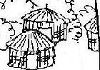
Yucayeques were built close to a water source.
Living in the tropics they enjoyed daily baths,
sometimes several in one day, and some being ritual
baths. Taínos most often built their homes around a
batey or plaza. The batey was used for areytos
(ceremonies), ball games, and dancing. Their round
thatch roofs homes were called bohíos. Bohíos were
made from, reed, bamboo and tree branches tied
together; grass was woven into them and they were
packed with mud. In every yucayeque there was one
great rectangular house where the cacique (chief)
lived called the caney. The bohique also lived in a
caney structure. The caneys were built in a central
location on the edge of the batey and the bohíos
completed the circle around the batey and the rest
of the yucayeque.
Bohíos did not have much furniture. Taínos slept on
cotton nets that hung from the ceiling called
hamacas (hammocks). Hamacas were also used to sit on
or to move sick people around in much like a
hospital gurney. Taínos sat on dujos. Dujos were
short four legged seats with back rests. Most were
carved with religious symbols and some were
elaborately carved and decorated with gold and
semiprecious stones. The cacique's dujo had a taller
back rest.
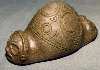 |
Taínos carved cemís (idols) from wood,
stone, and clay. Cemís were said to
encompass the spirit of the god Yucahú.
Cemís came in all sizes and mostly were
three pointers. Nitaínos carved elaborate
cemís and some were painted and decorated
with gold and precious stones. |
Areytos were religious ceremonies that sometimes
lasted several days. Caciques and Bohikes wore a
ceremonial cape at the areytos called a Mao. A Mao
was a round white cotton cover with a center hole
that covered the shoulder, chest and back. The Mao
was a status symbol.
During areytos the bohike taught the history of the
Taínos, the history of their particular yucayeque,
told battle stories, related important historical
events and taught religion and tradition. There was
a lot of ceremonial music, song, and dance at
areytos. A ceremonial game was also played in the
ball-game courts. Areytos were held for different
reasons maybe the wedding of the cacique, or the
birth of his child, or even just when important
guests arrived. Children had the most fun at areytos.
They dressed up by decorating their bodies with
paint and wearing jewelry. There was lots of foods
and games to play with their friends. Children were
an important part of the festivities.
Music was an important part of Taíno life. Their
drums were hollowed tree trunks that were hit with
sticks to produce rhythmic sounds. They made shakers
called maracas out of hollowed out gourds. Güiros
were a rhythmic instrument made from the marimbo
gourd. These musical instruments are a legacy of the
Taínos and are still used today. Children learned to
play instruments early and helped their parents make
the instruments.
Not much hunting went on because there was no large
game on the island. But Taínos hunted birds,
manatees, snakes, parrots, jutías (small rodents),
iguanas and waterfowl. The Taínos would hollow a
calabash, cutting "eye holes" into it. They would
wear the calabash on their head while submerged in
rivers or beaches and thus were able to catch birds
by grabbing them by the legs. They would use hats
covered with leaves to catch parrots - a delicacy.
The men cooked on a BBQ - and this is where our
modern BBQ comes from. Taíno children had fun
wearing a calabash hunting hat to catch parrots for
snacks.
Taíno weapons consisted of the baira (bow) and the
arrow, the manaya (hatchet) and the macana (war
club) made out of Guayacan wood.
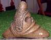
Cemí |
Puerto Rico
is located in the Caribbean Ocean. It is the smallest of the
Greater Antilles Islands, which include Cuba (the largest),
Haiti and the República Dominicana (sharing an island), and
Jamaica. Puerto Rico is only 100 miles long by 35 miles wide. It
is 1000 miles from Miami.
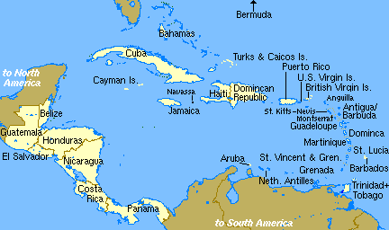
Puerto
Rico is often referred to as Borinquen or Borikén, indigenous
names, as well as Isla del Encanto, and Perla del Caribe. Puerto
Ricans refer to themselves as Puertorriqueños or Boricuas.
Boricua is used as a term of endearment and cultural
affirmation.
|
Before the Spaniards discovered Puerto Rico, it was
populated by Taíno Indians. The Taínos were a peaceful,
gentle nation. They welcomed the conquistadores and
shared their homes and food and gave the Spaniards many
gifts. |
Christopher Columbus sailed from Spain in his second voyage and
discovered Puerto Rico on November 19, 1493. He named the island
San Juan Bautista. Columbus thought this island to be very
beautiful and wrote so in his diary. Soon after, the island's
name was changed to Puerto Rico.
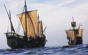
Columbus's on his second voyage depart Spain with 17 ships.
Juan Ponce
de León colonized Borinquen in 1508 and became its first
governor. The Spaniard conquistadores were looking for gold.
They made slaves of the Indians slowly killing them from
overwork. Soon thereafter African families were brought to the
island as slaves.
|
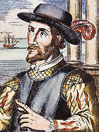
Juan Ponce de
León, the explorer, was born in Valencia, Spain, in
1460. As a teenager he joined Spanish forces that
defeated the Moors. In 1493 he accompanied Cristóforo
Colombo in his second voyage to America. Later Ponce de
León was granted a commission to explore Borinquen. He
then set out to colonize the island of San Juan Bautista
and build the first settlement called Caparra. He served
as first governor from 1509-12. During his term as
governor the island's name was changed from San Juan
Bautista to Puerto Rico.
Ponce de Leon went
on to achieve other accomplishments. His tomb is found
at the San Juan Cathedral in Old San Juan. His family
estate is the Casa Blanca, another popular tourist site.
|
|
Many
families from Spain and other European nations moved to the
island. Slowly Taíno Indians married either Africans or
Europeans forming a new ethnic group called Criollos. Today
there are many European, African, and Criollo families in Puerto
Rico.
|
PUERTO RICO U.S.A.
On
July 25th, 1898 the United States invaded Puerto Rico
through the port of Guanica. Puerto Rico was granted to
the United States with the Treaty of Paris after the
Spanish American War in 1898. The island was under
American Military rule until La Ley Foraker in 1900,
which established a civil government headed by appointed
governors - all of them U.S. Americans.
La
Ley Foraker also established the post of Resident
Commissioner, giving Puerto Ricans a non voting
representative in the U.S. Congress. In 1917 La Ley
Jones granted Puerto Ricans American citizenship - just
in time to draft them into the Armed Forces.
In
1952 Puerto Rico became a Commonwealth of the United
States giving islanders "limited" self-rule - much like
a state. There is an elected governor, and an elected
Congress with two houses, the Senate and the House of
Representatives. Puerto Ricans do not vote in
presidential elections unless they reside in one of the
states.
Spanish is the native language but many people speak
English as well. Many Boricuas have joined the U.S.
Armed forces and have fought in all wars from 1917.
Many, many Puerto Rican soldiers have received medals
for their bravery. The 65th Infantry Division, made up
solely of Puerto Ricans, became the most decorated Army
unit in Korea at that time.
Today
Puerto Rico has become one of the most modern Latin
American countries. There are highways and freeways,
hospitals, schools, many universities and colleges,
museums, malls, fast food chain restaurants as well as
local restaurants. There is a modern telephone system,
cable television, satellite TV, and Internet. All the
modern conveniences found in the states are enjoyed by
islanders. San Juan is a modern city comparable to any
in the mainland United States.
Puerto Rico is becoming the gateway to Latino America.
What other Latino American country has such close ties
to the United States?
This lesson
will teach the basic geography of Puerto Rico.
The island of
Puerto Rico is found in the Caribbean Sea,
approximately 1,000 miles from Miami. It is surrounded
by the Atlantic Ocean to the north, the
Caribbean Sea to the south, the Virgin Passage to
the East and the Mona Passage to the West.
Puerto Rico is the smallest of the Greater Antilles
Islands which include, Cuba (the largest), Española
(República Dominicana and Haiti - sharing an island),
and Jamaica.
Puerto Rico
includes several small islands the largest of which are
Vieques, Culebra, and Mona. The island of Puerto Rico is
approximately 111 miles long (East to West) and 36 miles
wide (north to south). Puerto Rico has 3,417.5 square
miles (including all islands).
Puerto Rico is one
among hundreds of small islands formed approximately 185
million years ago when a large shift of tectonic plates
sank some areas and pushed other areas upward forming
small islands. So Puerto Rico is the top of a range of
mountains which were pushed upwards from the Atlantic
Ocean.
Puerto Rico has a
range of mountains in the center called la Cordillera
Central rising to 4,390 feet at the highest point called
Cerro Punta in Jayuya. The mountain slopes are fertile
and green. Along the coast are fertile plains. The only
tropical rain forest in the U.S. National Forest System
is found in eastern Puerto Rico. It is called The
Caribbean National Rain Forest known as El Yunque. A
small southwest corner of the island is an arid area
with dry desert vegetation. There are many small rivers
the largest of which are Río de la Plata, Río Grande de
Loíza, Rí Grande de Manatí, and Río Grande de Arecibo.
Over 300 miles of coast rim the island shaded by coconut
palms.
Puerto Rico's
climate is tropical so the climate is usually sunny,
very hot, and humid. There is no winter, spring or fall,
only summertime. There are northeasterly winds that help
keep the temperature comfortable. The average
temperature is 82 degrees with a 12 degree variation.
There is more rain in the north than in the south.
The Capital of
Puerto Rico is San Juan. San Juan was the first town
established in the island by colonizer Juan Ponce de
León. Two of the earliest towns are San Germán (second
town) and Coamo, at one time considered the capital of
the south. Other important cities are: Ponce on the
south (known also as the southern port city), and
Mayagüez on the western shores. The metropolitan area
that includes San Juan to Bayamón are the most populated
area with approximately one third of the island's total
population.
Geography of Puerto Rico
Word Search - Vocabulary Exercise
| C |
O |
I |
I |
S |
L |
A |
N |
D |
O |
M |
C |
R |
C |
F |
Z |
| E |
L |
Y |
U |
N |
Q |
U |
E |
P |
C |
O |
U |
I |
O |
E |
M |
|
L |
E |
Y |
N |
C |
E |
N |
N |
R |
E |
U |
B |
C |
R |
R |
P |
|
R |
A |
C |
A |
R |
I |
B |
B |
E |
A |
N |
A |
O |
D |
T |
U |
|
T |
T |
E |
C |
T |
O |
N |
I |
C |
N |
T |
T |
O |
I |
I |
E |
|
R |
P |
O |
N |
C |
E |
T |
O |
N |
I |
A |
A |
P |
L |
L |
R |
|
O |
A |
N |
T |
I |
L |
L |
E |
S |
L |
I |
I |
A |
L |
E |
T |
|
P |
O |
U |
L |
O |
I |
Z |
A |
T |
A |
N |
N |
N |
E |
A |
O |
|
I |
X |
C |
O |
C |
O |
N |
U |
T |
T |
U |
R |
L |
R |
E |
R |
|
C |
Y |
T |
E |
M |
P |
E |
R |
A |
T |
U |
R |
E |
A |
R |
I |
|
A |
A |
T |
L |
A |
N |
T |
I |
C |
M |
O |
N |
A |
O |
I |
C |
|
L |
T |
N |
M |
G |
E |
O |
G |
R |
A |
P |
H |
Y |
A |
O |
O |
1. Sea on the South shores.
2. Name of our topic of study
3. Ocean on the North shores.
4. Puerto Rico is the smallest of these.
5. Central mountainous region
6. Puerto Rico's climate
7. Name of Rain Forest
8. Spanish for river
9. River that begins with "L"
10. Science we are studying
11. Plates that move under ocean floor
12. Surrounded by water on all sides
13. Body of water
14. Formation in the middle of island
15. Soil condition
16. Heat measurement
17. Palm that shade beach
18. Largest of the Greater Antilles
19. Important Southern city
20. Small island (begins with M)
Answers bellow but in white :
Caribbean,
Puerto Rico, Atlantic, Antilles, Cordillera, tropical,
El Yunque, rio, Loiza, geography, tectonic, island,
ocean, mountain, fertile, temperature, Cuba, Ponce,
Mona, coconut.
|
|