|
L a G r a n E n c i c l o p e d
i a I l u s t r a d a d e l P r o y e c t o S a l ó n H o
g a r

|
|
|
Puerto Rico English
version
|

Para poder
tomar los exámenes
de este
tema debes estar
registrado,
si no lo estás,
Registrate
aquí
|
|
map
location, the antilles,
surface features of puerto rico,
maritime,
forests & wildlife
preserves, caverns,
natural resources,
hydrography,
climate,
natural hazards,
energy,
flora, fauna, society, government &
politics, economy, industries, agriculture, capital & major cities
Map Location
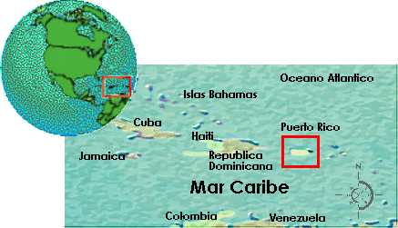
Por: Profesora Rosa Valerio
The Antilles
The Island of Puerto Rico is
part of the Caribbean archipelago, the Antilles. It's geographic coordinates
are latitude 18-15 N and longitude 66-30 W, which puts it about 1,000 miles
(1,600 km) southeast of Miami, Florida U.S.A. The Antilles is a chain of
islands located in the; Caribbean Sea; The largest islands Puerto Rico,
Cuba, Jamaica and Hispañola (Haiti and the Dominican Republic) make up the
Greater Antilles, Puerto Rico being the easternmost and smallest of this
group. The Lesser Antilles, located east and southeast of Puerto Rico, are
made up of dozens of smaller islands, including the Virgin Islands,
Martinique, Barbados and Trinidad to name a few. Although the islands of the
Antilles are relatively close in proximity and share a common history, a
cultural and political diversity is characteristic of the region. And,
Puerto Rico is without exception.
The Commonwealth of Puerto Rico
(in Spanish, "Estado Libre Asociado de Puerto Rico"), is a freely associated
commonwealth of the United States, composed of one large island and several
small islands named Culebra, Desecheo, Mona, and Vieques. A host of smaller
cays and islets including Culebrita, Monito, and Palomino are associated
with Puerto Rico, as well.
Puerto Rico is bound at the
north by the Atlantic Ocean and at the south by the Caribbean Sea. It is
bound at the east by the Virgin Islands and on the west by La Hispañola. |
|
TOP |
|
Surface
Features
Puerto Rico is a mountainous, tropical island
roughly rectangular in shape. At it's widest points the Island measures
65 km (about 40 mi) from north to south and about 180 km (about 110 mi) from
east to west. It's total area amounts to 9104 sq km (3515 sq mi), and it
boasts more than 580 km (360 mi) of beautiful coastline.
Puerto Rico's geographic diversity includes
several mountain ranges, a mountainous rain forest, karst areas, arid
desert-like regions, beaches, caves, rivers and oceans. The prominent
geographical features that characterize the island can be found in it's
interior
mountainous regions, karst
areas and flatlands.
|
|
TOP |
Interior Mountainous Regions
About 80% of Puerto Rico's territory is
mountainous and hilly. The principal mountain ranges include
La Cordillera Central,
La Sierra Bermeja,
La Sierra de Cayey
and La Sierra de Luquillo.
These mountains reach about an average elevation of 915m (about 3000 ft).
The most prominent of these
masses is a central mountain chain known as "La
Cordillera Central." This geographical anomaly amounts to an extensive
mountain range, that transects the length of the island east to west from
Aibonito to the outskirts of Mayagüeze, and divides the country into
distinct north and south regions. It's highest peak, and the country's
highest point, is Cerro de Punta. This 1338 m (4,398 ft) point is located
just south of Jayuya at the western outskirts of the Toro Negro Forest. For
the most part, La Cordillera Central runs closer to the southern coast. The
slopes are steeper on this side, as well. Rain fall is more frequent on the
northern side.
At the
west end of the island La Cordillera Central faces the sea in an abrupt
steepness, but not before branching out to form La Sierra Bermeja mountain
range. La Sierra Bermeja is the smallest branch of the Central Mountain
ranges. With an elevation of about a 1000 ft., it extend from Guánica to the
southwestern tip of the island.
The mountain rage of
La Sierra de Cayey is an extension of La
Cordillera Central. It begins at Cayey and runs east to Humacao. At the
easternmost regions its elevation approaches only 400 ft. and concludes in a
fork of two low ranges, the Sierra Guardarraya and Cuchillas de Panduras.
These mountains extend southeast between Yabucoa and Patillas, and culminate
near the southeast coast and the Caribbean Sea.
In their
approach toward the eastern part of the island, the central mountains also
branch tnortheastward and form another mountain chain, La Sierra De
Luquillo. This mountain range runs from Gurabo to Fajardo, as several high
peaks, including Toro Hill at 1,074m (3524 ft), El Yunque at 1,065m (3,494
ft) and El Pico Oeste at 1041m (3416 ft). |
|
TOP |
Karst Areas
*Karst regions are concentrated along several
areas in northern Puerto Rico. Most of the formations extend from Aguadilla
on the west coast to the center of the island. Scarce pockets of small hilly
karst formations are scattered east all the way to Loíza.
Near the coast limestone
deposits, a major characteristic of karst regions, form a vast regiment of
rolling hills, that resemble haystacks laid arbitrarily across the land.
These limestone deposits were formed by volcanic rock as the island rose out
from the sea millions of years ago.
South of the coast, approaching
the interior mountainous regions of the island, the most common features
associated with this karst topography, include rolling hills, sinks,
sinkhole underground streams and rivers, limestone plateaus and a labyrinth
cave system (much of it unexplored).
The process that creates these
natural forms is simple, but takes millions of years to achieve. The
ceilings of subterranean caverns eventually fold causing depressions at the
surface of the ground. These impressions are what form the karst hills,
sinks and sinkholes. Streams from rainwater drain into sinks, revealing the
presence of caves underneath. Underground streams and rivers flowing through
these caverns are constantly replenished, and as a result, the currents
continuously wear away the porous limestone and creates more caverns and
depressions. This cycle has existed for countless millenniums.
Some places of interest with
good examples of karst topography include Rio Abajo Forest, Guajataca
Forest, Dos Bocas Lake, Rio Camuy Cave Park and several points on the Camuy
River. Rio Abajo Forest, and Dos Bocas Lake have a fine display of tropical
karst topography. Numerous cone-shaped hills covered in tropical vegetation
make up the rolling landscape. The Guajataca Forest features some 25 miles
of well-marked trails along it's typical karst landscapes. Here, you will
find minerals ranging from stalagmites, stalactites and other sediment
formations.
The Rio de Camuy Cave Park hosts
one of the largest underground rivers in the world, the Rio de Camuy.
The Park also has an elaborate cave system. Many of the caves are as
yet unexplored. High ceilings, adorned by a diverse collections of
crystalline stalactite formations, grounds laden with random shaped
stalagmites and subterranean waterfalls are characteristic of these 45
million year old caves. Plants that inhabit these depths have very little
pigmentation. The region is so dim that fish have evolved without eyes. |
|
TOP |
Flatlands
The flatland is a geographical feature known for
it's low-lying and relatively flat regions. There are relatively few
flatland regions in Puerto Rico. They include narrow stretches of coastal
plains and inland valleys formed by the erosion of mountains millions of
years ago.
The flatlands or coastal plains that surround
the island are an extension of the submerged continental shelf that lies 200
meters deep. Fertile coastal plains that extend along the north coast reach
about 19 km (about 12 mi) inland. Small rivers, streams and plenty of rain
water common to this region, contributes to the landscape's lush appearance.
In contrast with the north, a tropical dry
coastal plain, covering on average about 13 km (about 8 mi) inland, blankets
the southern coast. Along the southwest coast the land is extremely arid and
receives very little rain fall.
Small valleys are sparsely situated
throughout the island, especially near the east and west coasts. El Valle
de Lajas is said to be the largest of them on the island.
|
|
TOP |
|
Maritime
The temperature of the seawater
surrounding Puerto Rico averages to some 27° C ( 81° F). Variation in
seawater temperature during the course of the year is negligible.
The lowest point in Puerto Rico is sea level
(Caribbean Sea 0 m). The Island is flanked on all sides by a submerged
continental shelve, that slopes from the shores to a depths of about 200
meters. Past this ledge the surrounding ocean waters become deep very
quickly.
Two miles north of Puerto Rico, below the
rough seas of the Atlantic, the ocean floor drops about 600 feet. At 45
miles (72.42 km) to 75 miles (120 km) out, the Oceans floor plunges deep
into what is called the Puerto Rico Trench or Bronson's Deep. The
depression, lies parallel to the northern coast and measures about 1,090
miles (1,750 km) long by 60 miles (100 km) wide. About 100 miles (160 km)
northwest of Puerto Rico, situated within the west end of the Puerto Rico
Trench, is the Milwaukee Deep. Measuring a depth of 27,493 feet (8,380
meters), it is considered the deepest depression in the North Atlantic
Ocean. The Trench, which has it's beginnings in the Tertiary period, has
been expanding for the past 70 million years. It is believed to belong to a
Carribean system of strike-slip faults with characteristics similar to the
Andreas fault in California. A diagram containing the outline and depth of
known trenches surrounding Puerto Rico is available below.
Click on the following image to enlarge
it. To return to this page click the back button on your browser.
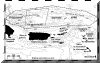
Map of the Puerto Rico trench indicating the
2002 surveyed region within the larger 2003 proposed survey area. Image
source provided by National Oceanic and Atmospheric Administration (NOAA) |
U.S. Department of Commerce at
Oceanexplorer.com
Off the West coast the Mona Passage divides
Puerto Rico from Hispañola. This key shipping lane to the Panama's is about
75 miles (120 km) wide and more than 3,300 feet (1,000 meters) deep. To the
South, the calmer Caribbean sea drops some 16,400 feet (5,000 meters) in
what is known as the Venezuelan Basin.
Puerto Rico's economic zone claims
sovereignty on 200 nautical miles (370 km/230 mi) offshore. This includes
exclusive rights to research, environmental protection and seabed minerals
development. The island's territorial waters, or boundaries that safeguard
it's rights to fishing, and other permissions extends some 12 nautical miles
out. |
|
TOP |
Forests & Wildlife Preserves
Scattered throughout the Island of Puerto
Rico is a network of vast forests and wildlife refuges. Various grades of
tropical jungles including rain forests, mangrove forests, a variety of
karst regions and subtropical dry lands feature a wide variety of plant and
tree species, intriguing trails, caves, cliffs and several water-holes
northern region,
eastern region,
central region,
southern region,
sister islands and
islets |
|
TOP |
Northern Region
The land on the north side of Puerto Rico is
generally wetter and lush with vegetation than land on the south side. Ample
rainfall and streams that flow down from La Cordillera Central chain
contributes to this fertile environment. Forests along the north side
include the Guajataca State Forest Reserve, Rio Abajo State Forest,
Cambalache State Forest, Vega Alta State Forest and Piñones Forest.
The Guajataca State Forest Reserve
covers an area, near Aguadilla, in the northwest karst region of Puerto
Rico. The Rio Abajo State Forest Reserve, located in the north
central part of the island, between Arecibo and Utuado, encompasses over
5,000 acres of karst woodlands, including limestone cave formations, trails
and natural spring water holes, tied to a scenic backdrop of surrounding
cliffs. The Reserve features the Camuy Caves, and Dos Bocas Lake. East
of this region, located near Barceloneta, stands the Cambalache State
Forest. It's wonderful display of tropical karst landscape is defined by
numerous lush cone-shaped hills spread randomly across the land. Beyond
this, just west of Dorado, is a relatively small woodland known as the
Vega Alta State Forest. Piñones Forest is a subtropical woodland
along the northeast region, just east of Isla Verde, San Juan.
|
|
TOP |
Eastern Region
El Yunque Rain Forest, known also as
the
Caribbean
National Forest, rest in the north-most corner of the east coast. These
28,000 acres of wetlands are all that remain of the rain forest that covered
much of the island more than five hundreds years ago. Cold mountain streams
and waterfalls are plentiful. The National Forest of la Condesa lies just
southwest of here. The State Forest of Ceiba is located adjacent to
El Yunque, off the east coast of the Island. This forest features a
subtropical dry woodland. The Humacao Wildlife Refuge is found South
of Ceiba along the shore of the Humacao region. The Preserve includes the
largest Pterocarpus trees in Puerto Rico and a lagoon system.
|
|
TOP |
Central Region
The Cordillera Central, is an extensive
mountain range that transects Puerto Rico from east to west along the
Island's central region. Here, huge mountain forests blanket the country
side at several locations from the ridge. The temperature is a typical 70 to
75 degrees during the day. At night it can drop to a cool 60 degrees. River
water at high elevations is clean enough to drink. Forests along the
Cordillera Central include Maricao Forest, the Susua State Forest, Lago
Lucchetti Wildlife Refuge, Monte Guilarte State Forest, Toro Negro Forest,
and Carite Forest.
The Maricao Forest is typical of the
island's woodlands. Situated along the west end of the Cordillera Central
vein, Maricao encompasses a vast territory northwest of Susua State Forest.
It features 845 species of flora, and 278 species of trees of which 123 are
endemic. Susúa State Forest is located in the western expanse of the
Cordillera Central foothills, opposite Lago Lucchetti Wildlife Refuge.
The Guilarte Forest Reserve is also located in this region, just west
of Adjuntas. This Reserve features a small eucalyptus forest, trails and 105
species of trees. North of the town of Villalba, midway along the Cordillera
Central, is the Toro Negro Forest. It boosts the highest peak, 1338 m
(4,398 ft), along the Cordillera Central and the highest geological
structure in all the island. It is also home to two of the highest lakes of
the land, Lake Matrullas and Lake Guineo. Here you will find the Salto de
Dona Juana (waterfall) and the San Cristobal Canyon, which measures 750
feet. The Carite or Guavate Forest is located in the eastern
region of the Cordillera Central, east of Cayey. |
|
TOP |
Southern Region
In general, there is less rainfall along the
south side of the Cordillera Central Mountains, so the land on the south
side of Puerto Rico is typically dryer than on the north side. This
subtropical arid condition is evident in the Cactus, and scrub-brush flora
and forests that flourish here. Forests along the south side of the island
include the Punta Guaniquilla Reserve, Cabo Rojo National Wildlife Refuge,
Boqueron State Forest, La Parguera Nature Reserve, Guánica Dry Forest,
Aguirre Forest Reserve, Punta Ballena Reserve, and Ines Maria Mendoza Nature
Reserve.
At the southwest region of the island the
Punta Guaniquilla Reserve and Bird Sanctuary portrays a good example of
the diverse environments contained in these parts. In this arid heaven you
will find lagoons, swamps, limestone and rock formations, caves, palm and
mangrove forests, cactus and other scrub vegetation. At the southwest tip of
the island in Boqueron, the Cabo Rojo National Wildlife Refuge and
the Boqueron State Forest lies separated by the Sierra Bermeja. On
the coast of Lajas, La Parguera Nature Reserve includes mangrove
keys, inlets and estuaries. Some 1,640 acres of subtropical dry land known
as Guánica Forest is located in the region between Ponce and Lajas.
The Forest has been declared an International Biosphere Reserve by UNESCO
because of it's unique dry forest vegetation. The mangrove forest of the
Punta Ballena Reserve is contiguous with the Guánica Dry Forest, and is
also a biosphere reserve. Further east lies the Aguerre Forest
Reserve, located between Arroyo and Salinas. The region features various
canals and mangroves. The Ines Maria Mendoza Nature Reserve in Punta
Yegua is a peninsula by the sea, located at the southeast tip of Puerto
Rico. Ortegon trees of the evergreen variety flourish here.
|
|
TOP |
Sister Islands and
Islets
Various sister islands and islets surrounding
Puerto Rico's mainland serve as wildlife refuges. These preserved heavens
include Isla De Mona Wildlife Refuge, Caja de Muertos Natural Reserve,
Desecheo Island Wildlife Preserve and The Natural Reserve of Mosquito Port
Bay.
Protected by the United States National Park
Service and the Puerto Rican Natural Resources Department, la Isla de Mona
Wildlife Refuge is located about 50 miles west of Cabo Rojo. This nature
refuge is a well balanced ecosystem, and features many trails, limestone
caves, cliffs and pristine shores. The variety of flora that thrives in this
environment is matched only by that on the Galapagos Islands. The Island of
Caja de Muertos is located 8.5 miles off Ponce's coast. The Natural Reserve
includes caves, cliffs, coral reefs, and mangroves. Desecheo Island Federal
Wildlife Preserve is located some 13 miles west of Rincon. This uninhabited
island contains a well preserved marine ecosystem. The Natural Reserve of
Mosquito Port Bay, in Vieques Island, includes one of the most brilliant
bioluminescent bay in the world. |
|
TOP |
|
Caverns
About 189 formations that qualify as cave
systems exist on the Island of Puerto Rico. A few of these areas are some of
the most astonishing geological creations this side of the globe. The
following describes some significant and unique caves on the Island.
|
|
TOP
|
Río Camuy Caves
In the karst region of the north central part
of the Island, one of the most spectacular and popular cave formations
exists along some 300-acres of porous limestone, known collectively as the
Rio Camuy cave system. This area features subterranean river caves with
attributes that include high ceilings and curving walls adorned with an
assortment of crystalline stalactite formations, floors carpeted by various
shaped stalagmites, subterranean waterfalls and miles of uncharted canals.
The caves were known to be a sacred place for
the indigenous Taino Indians, who believed that man was born from these
cavities. Today we know that the subterranean formations are the sum of 45
million years of gradual transformation. As the Camuy River flows across
this region, it's constant force erodes the surrounding limestone rock and
shapes the caves in the process.
Some popular cave sites in this region
include the Rio Camuy Mine, where semi-precious stones are common. In the
Cathedral Cave (named for it's high ceiling) ancient pictographs by Taino
Indians are inscribed on cave walls. And finally, the 170-foot high Cueva
Clara has become a popular point for rappelling and amateur exploration.
Plants and fish exist in these caverns, and have adapted to these dark
recesses by evolving physically. |
|
TOP
|
Cueva del Infierno
Cueva del Infierno is located near the Rio
Camuy Caves, and comprises some 2,000 of it's own caverns.
|
|
TOP
|
Cueva Del Indio
Cueva Del Indio is located on the north coast
of Puerto Rico, just past the Hallows, in La Punta Caracoles. These ancient
caves are know for the Indian Paintings inscribed on their walls. |
|
TOP
|
La Cuerva del Viento
You'll find La Cuerva del Viento ("the cave
of the wind"), west of the Río Camuy Cave Park, in the northern karst hills
of the Guajataca Forest. This cave network includes 11 wind caves. Explorers
can descend a ladder into a cavern where you'll find stalagmites,
stalactites and other sediment formations. |
|
TOP
|
Foza Aldea
Archaeological relics from the first century
A.D. were found at cave sites, near the northeast coast around Foza Aldea.
This finding yielded conclusive evidence that Puerto Rico has been inhabited
for at least two thousand years. |
|
TOP
|
Underwater caverns (Shacks Beach)
At the northwest coast near Shacks Beach, a
maze of walls 40 feet deep are the framework for some underwater caverns. |
|
TOP
|
Mona Island
Off the west coast mainland of Puerto Rico
the uninhabited island of Mona hosts numerous caves. |
|
TOP
|
|
Natural Resources
Puerto Rico's natural wealth
includes some minor fishing, several rich soil types, and an abundance of
mineral deposits.
|
|
TOP
|
|
Mineral Deposits
On the Island opportunity for
mineral production is considerable. The worth from minerals presently being
mined draws well over 160 million annually.
Mining for minerals returns
primarily construction materials, like cement, sand, gravel, and stone.
In lesser quantities, but by no means less valuable, mineral production of
deposits such as limestone, clay, copper, magnesium, mercury, zinc, lead,
cobalt, chromium, nickel, iron ore, peat, graphite, salt, and tin also
exist.
Surveys have uncovered
concentrations amounting to 35 million lbs. of copper, 1,241 oz. of gold and
6,295 oz. of silver at the center of the island near Adjuntas (Puerto Rico’s
Mining region), Utuado, Jayuya, and Lares. Puerto Rico also has potential
for on-shore and off-shore crude oil production. The decision to exploit
these minerals is constantly weighted against the social and ecological
costs such as air pollution, water pollution, and disruption of the natural
landscape and soil.
The Puerto Rican State Forest in
Adjuntas is a good example of officially preserved land that had once been
destined for open pit-mining operations. On September of 1996, about 700
acres of this region were handed over to the Department of Natural and
Environmental Resources by the government of Puerto Rico’s Land Authority
for public use. |
|
TOP
|
|
Soil
When it comes to soil, Puerto
Rico contains almost every major soil group of the earth. Tropical
soils are considered uncultivable and of little agricultural worth. Yet,
regions like Puerto Rico have traditionally provided high biomass products
like bananas, coffee, sugar cane and tobacco. |
|
TOP
|
|
Soil Classification
A scientific classification by
the U.S. Soil Conservation Service, summarizes soil in Puerto Rico into five
general types: humid coastal plains, semiarid coastal plains, humid uplands,
semiarid uplands, and humid upland valleys. Another classification by
specialists at the University of Puerto Rico, summarizes the island's soils
into coastal lowlands, alluvium, coastal plains, alluvium in terraces,
upland dark, and upland reddish-purple. |
|
TOP
|
|
TOP
|
|
Hydrography
There exists over 1,200 bodies of water in Puerto Rico that
can be classified as either rivers, lakes, lagoons, mangroves and streams.
The description below includes those aquatic formations noteworthy for their
class. |
|
TOP
|
Rivers
Most of the island's rivers are narrow and
shallow, extend relatively short distances, and for the most part, are not
navigable by large vessels except in a few areas near the coast. There
exists as many as 50 rivers most of which flow down from the northern
mountain sides to the sea. Several of these bodies are utilized for
electrical power and irrigation.
The northern rivers are longer,
and have tranquil waters in comparison to the southern rivers. Rivers that
flow from the north side of the Central Mountain Ranges sustain the lush
coastal plain belt of the north. In the south where it is typically arid,
smaller rivers and streams tend to dry up fast. In spite of this, heavy
rainfall will quickly cause extreme flooding even under these circumstances.
|
|
TOP
|
|
Puerto Rico's longest rivers
include Grande de Añasco, Rio Culebrinas, Grande de Arecibo, Rio de La
Plata, Rio de Bayamón and Grande de Loíza. These rivers drain to the north
coast, except for Añasco and Culebrinas which drain to the west.
On the western region of the Island, Rio Grande de Añasco extends out about
65 km, and is part of a system of rivers that flows down from the Cordillera
Central. The river Añasco flanks the south side of the town of Añasco and
ends at the west coast. Also in this region is the Rio Culebrinas,
which flows passed Lares and San Sebastian from 45 km in land, and comes to
an end at the west coast between Aguada and Aguadilla.
El Grande de Arecibo extends
about 55 km. It flows from one leg of Los Dos Bocas Lake, and continues
north all the way to the coast. Rio de La Plata extends about 80 km from
north to south, practically transecting the Island. The river forms out of
Lago Carite, in the eastern region of the central mountain range. Just above
Naranjito, the river flows in and out of Lago La Plata. It passes near Toa
Alta and Toa Baja, then flanks Dorado to the east before draining into the
Atlantic. Rio Bayamón extends 40 km from Lago de Cidra to the Atlantic
coast. It crosses Guaynabo and Bayamón on it's way. Rio Grande de Loíza
extends about 65 km from Lago Loíza, and flows north, zigzagging across
Trujillo Alto, Carolina and Loíza. |
|
TOP
|
|
The Rio Camuy is a popular river, but not for it's length or breadth. It has
distinctive geological features rivaled around the world by only a few
rivers in it's class. Located in the northwest quadrant of the island, the
Camuy river flows north from the mountains and submerges below ground at
several locations to become a subterranean river within the karsts regions
of Camuy. |
|
TOP
|
|
Lakes
In Puerto Rico the typical lake
is man made and relatively small. The reservoirs were formed by damming the
major rivers to produce hydroelectric power and water for land irrigation.
Some significant lakes worth mentioning are scattered throughout the north,
central and south regions of the island. |
|
TOP
|
|
North Lakes
On the north side of the island there are
many lakes situated throughout the interior. Located between Caguas, Gurabo
and Trujillo Alto, Lake Loíza (Carraizo) covers an area of about 84 square
kilometers, and it is by far the largest lake in Puerto Rico. Lake La Plata
has an area of 67 square kilometers, and is the second largest. It's located
several miles north of Naranjito in the northeast quadrant of Puerto
Rico. The third largest lake, Dos Boca's, is situated less than 5 miles
northeast of Utuado. You'll find lake Guajataca in the northwest quadrant
near the Guajataca Forest, and south of Quebradillas. |
|
TOP
|
Central Lakes
Some popular lakes can also be found in Puerto
Rico's central region. Lake Caonillas covers an area of 19 square kilometers
east of the town of Utuado. Lake Garzas is a small lake, situated in the
Guilarte Forest and west of the town of Adjuntas. Located in the Toro Negro
Forest on the Cordillera Central Mountain Range, Lake Guineo and Lake
Matrullas are two of the highest lakes on the island. Lake Cidra has an area
amounting to 3 square kilometers. This is one of the smallest lakes on the
island. It's located just east of the town of Cidra. Finally, Lago Guayo
lies between Adjuntas and Lares. |
|
TOP
|
South Lakes
On the south side of the island, visitors
will find many spectacular lakes including Lake Guayabal. This basin is
located in the Pastillo district of Juana Díaz. Lake Toa Vaca is situated
south of the town of Villalba. Lake Carite is in the Carite Forest,
southeast of Cayey. Lake Patillas is located in Patillas. And, Lago
Cerrillos is located just above the town of Ponce. |
|
TOP
|
Lagoons
Noteworthy is a number of
typical tropical lagoons located throughout the island. They include Laguna
de Piñones and Laguna de Torrecillas in Piñones State Forest, Carolina;
Laguna Los Corozos and Laguna San Jose off of Isla Verde, San Juan; Laguna
Tortuguero in Manatí-Vega Baja; Laguna Joyuda, Laguna Cartagena and Laguna
Boquerón, are all located in Cabo Rojo. You will also find Laguna de Guánica
in Lajas; Laguna de las Salinas off of Ponce; Laguna de las Mareas in
Guayama; Laguna Aguas Prietas in Fajardo; and Laguna Kiani and Laguna
Anones, both located on the island of Vieques. |
|
TOP
|
|
Mangroves, Thermal Pools & Streams
There are a few mangroves
scattered throughout the island that are worth mentioning. In the southwest
region, time has created an unique canal system in the mangroves of Lajas.
At La Parguera Nature Reserve various inlets along the coast, offer an
entrance to a maze of narrow channels known as the mangrove forest.
Mangroves can also be found in Vieques and the Guanica state forest.
Other water masses known for
their rare characteristics include "Los Baños de Coamo." These natural hot
baths, located near the south central lake of Coamo feature natural thermal
pools that are relaxing and invigorating.
There are more than 1,000 small
streams on the island. Streams are plentiful especially after heavy rains.
Subterranean streams are abundant, especially in the northwest karsts
region. |
|
TOP
|
|
Climate
Puerto Rico's climate varies by location. The
Island has tropical weather at low altitude and subtropical at higher
altitudes. Winds, mountains and sea temperatures also play a major roll in
the variations of rainfall and temperature throughout the land.
|
|
TOP
|
|
Rainfall
During the hot months warm
seawater (about 81° F) surrounding the island, release vapors, that sweep
above the cooler mountains on northeast trade winds to form rain.
The rainy season occurs between
May and December. A dryer period appears around December and can last till
March. The north region, and especially the mountain areas, receives the
most precipitation. The southwestern coastal region is characterized by a
dryer term. This disparity is evident in the 189 inches of annual rain that
falls over El Yunque Rain Forest in the north and the 40 inches that fall on
the city of Ponce in the south.
Annual rainfall
averages about 1,550 mm (161 inches) in the north, 910 mm (36 inches) in the
south, 101-381 cm (40-150 inches) in coastal regions and 508 cm (200 inches)
in the mountains. |
|
TOP
|
|
Temperature
Though northeast trade winds
regulate and cool the air considerably, the weather in Puerto Rico is
typically warm, humid, with lots of sun, especially during the summer.
The average annual temperature
varies from 78 to 82 degrees Fahrenheit. Temperatures along the interior,
varies between 73 and 78 degrees Fahrenheit. The south is usually a few
degrees higher than the north. The coolest temperatures on the island exist
in the interior mountains.
Some record breaking
temperatures in Puerto Rico include a recording of 4.4° C (40° F) in 1911 at
Aibonito, and 39.4° C (103° F) in 1906 at San Lorenzo.
|
The city of San Juan,
receives some 1500 mm (some 59 in) of precipitation yearly. Average
temperature ranges from 27° C (81° F) in July to 24° C (75 ° F) in
January. |
|
|
TOP
|
Natural Hazards
Hurricanes
Puerto Rico faces its share of
hurricanes, which commonly cross the Caribbean from the east. Sometimes
these power-wheeling cyclones come close enough to do serious damage.
During hurricane season, these
natural phenomena's are more common between August and October. Some
have reached gale-force winds of over 200 mile per hour. Accompanied by
torrential rain, these storms leave in their wake a trail of immense
destruction. One of the most destructive hurricanes to reach Puerto Rico was
San Ciriaco, which struck on Aug. 8, 1899.
Next to flooding, erosions
(landslides) are ones of the greatest concerns when hurricanes hit. Roads
can be blocked by debris, and wooden homes and other frail structures are no
match for the enormous moving force. Small towns can be isolated for periods
of time, leaving residents stranded without electricity and telephone
service.
Evacuation plans put into affect
by the Puerto Rico Civil Defense Department keeps fatalities to a minimum.
|
|
TOP
|
Drought
On the opposite end of the scale, periodic drought is another
natural hazard occasionally facing the people in Puerto Rico.
Uncommon, yet searing temperature and the lack of rainfall causes water
levels in reservoirs to drop considerably enough to warrant water rationing.
|
|
TOP
|
|
Energy
Electricity
Puerto Rico uses thermal power
plants, run on refined petroleum, to generate most of the islands
electricity. Less than 1% of electricity is generated from hydroelectric
technology. A hydroelectric installation generates electricity by utilizing
the stored power derived from damming a river. All of Puerto Rico's
lake basins were created as a result of this process. |
|
TOP
|
|
Energy Consumption
Oil is the dominant fuel in
Puerto Rico. The amount of motor gasoline consumed is equivalent to
2,550,000 metric tons of coal. Energy Consumption is measured at 2,493 kwh
per capita. |
|
TOP
|
|
Flora
Numerous species of flora thrive in Puerto
Rico. Common tropical species like the Coconut Palm and Banana tree are
abundant all across the island. Species that are rare for the tropics, and
those with traits exclusive to the Island are found in various areas of
particular climates.
Some trees and shrubs are known for their
radiant colored bloom. The Poinciana, a prickly tropical shrub with bright
reddish blossoms, and the flamboyán, easily recognized by its blossoms of
vivid color, are very popular around the island. The White Cedar looses its
leaves beginning in April and blooms dazzling pink flowers by July. The
Hibiscus (Thespesia grandiflora, Maga grandiflora and Montezuma) is the
National Flower of Puerto Rico. Our national tree, the drought-resistant
Ceiba or Silk-cotton grows primarily in the arid south. Some trees like the
ancient Ausubo are a part of our islands history. Wood from the Ausubo was
used to produce the structural beams in many of the historic buildings in
Old San Juan.
|
|
TOP
|
|
Some trees like the Sugar Cane, Quenepa, and
Mango grow produce that is simply delectably right off the branch. The
popular tropical Coconut Palm and Small Banana (niños) tree also bare fruit.
Others, like the Gandules, Avacado and Green Banana tree, have been a part
of the Puerto Rican diet for generations.
You'll find unique and exotic species of
flora in all of the Forests of Puerto Rico. The Caribbean National Forest
(El Yunque) is no exception. Located in the northeastern section of the
island, this lush 28,000-acre preserve contains some 240 varieties of trees
and plants, including tree Ferns, Wild Orchids, Satinwood, Mahogany and
Spanish Elm.
Life grows just about everywhere on the
island. Even in the subterranean Camuy River Caves, up north. Here, beneath
the karsts region there is very little light, and plants with almost no
pigmentation, have found their place through ions of evolution.
|
|
TOP
|
|
Mangroves are found throughout the island's
coasts and are most impressive at the Guánica Dry Forest. The Forest is
located in the dry south, and harbors some 700 plant species, of which 48
are endangered and 16 exist exclusively on the island. Scrub brush, cactus
and other scrub species thrive in this arid environment.
50 miles off the west coast of Puerto Rico, a
variety of unique species, can be found on the uninhabited island of Mona.
|
|
TOP
|
Fauna
In Puerto Rico, many species of fauna thrive,
from the heights of El Yunque Rainforest to the darkest recess of the Río
Camuy caves.
Common livestock including cattle, horses,
sheep, goats, pigs and fowl are the largest mammals to reside on the island.
Iguanas and many small lizards are also natural inhabitants, though Iguana
sightings have steadily grown rare on the mainland. The mongoose lives here
as well, and was introduced to Puerto Rico as a means to control the rodent
population on sugar cane plantations.
|
|
TOP
|
|
Of the few indigenous animals that live in
Puerto Rico, the small (up to an inch long) Coquí frog is the most obvious
if not the most popular. At night these tree dweller chant a cricket like
chirp, "ko-kee,"
continuously in harmonious syncopation.
Another indigenous species the rare Puerto
Rican Parrot (Amazona vittata) is less visible to the public. The almost
foot tall bird lives in several secluded areas of the Caribbean National
Forest (El Yunque), and is recognized for it's bright green coat, red
forehead and wing feathers with a prominent shade of blue. It is one of two
hundred or so species of birds that either live or migrate here annually.
|
|
TOP
|
|
Caves such as the Río Camuy and El Cueva del
Infierno are known for their caverns, and the wildlife that resides within
these subterranean dwellings. Various animals and insects reside here,
including over 13 species of bats, the coquí frog, and the "guavá" arachnid.
The most pristine environment for wildlife
can be found on Mona Island, off the west coast of the mainland. Comparable
only by the Galapagos, this wildlife haven harbors a multitude of species,
some of which are exclusive to Puerto Rico.
Barracuda, kingfish, lobster, mackerel,
mullet, tuna, oysters and big game fish are common along the coastal waters
off Puerto Rico. You'll find the rare leatherback turtles nest-hole on the
island of Culebra, and during the winter season humpback whales migrate off
the west coast.
>>History
Next
>>> |
|
|
Fundación
Educativa Héctor A. García |

